
|


LaserMap for Windows CE
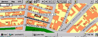
First product that combines Global Positioning System (GPS) technology
with detailed street vactor based layer separated maps for the Windows CE platform
(available since April 26, 1998). The LaserMap software records and track position
worldwide with automatic map display. The software includes detailed map of Moscow
(Russian Federation) with option to importing and purshase vector maps for other
countries.
 
1x1 screen
copy
Features:
|
vector based layer separated map data structure;
economical use of the operational system and computer resources:
original map data store format, developed specially for Windows CE, with using
on the fly data compression technology and principle "one map - one file"
the same map data format used both for Win32 and WinCE platforms
best route tracing;
North on top and course on top map image displaying modes;
intuitively clear interface
built-in help system
zoom in/out - see the whole world or just a few streets
pan entire map area at one time
dynamic names positioning - all names are displayed inside current map windows
special rotatable font supported
possibility of interactive customization layers show rules and displaying parameters
of the map objects
modes for image "dragging" and "selection" displayed window border limits
work with most popular GPS recievers (NMEA 0183 v.2.0 compatible) with RS232
customization option
special mode for moving map window according GPS position movement for showing
your current position inside a screen
map moving Undo/Redo commands
record, store, reply and export a route
displays sattelites position and signal level and you position coordinates
in real time
supports Windows CE 2.1x, Pocket PC and Windows 95/98/NT
|
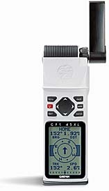
 Garmin 45XL
|
New versions
info
Free downloads
Return to
the main LaserMap page
Designed by V.Osipkov
(vctos@email.com)
This Windows CE Web CommunityWebring
site is owned by Victor Osipkov
Want to join the Windows
CE Web Community?
|


